Savvy Navvy can show your boat’s own depth, wind, heading and speed, instead of guessing from your phone’s GPS. Its NMEA Connect feature reads them over Wi-Fi from an NMEA gateway, and the Nauti-Control controller (N2K Wireless or ST Wireless) is one. Here’s how to set it up. It takes about a minute.

What You Need
- A Nauti-Control N2K Wireless or ST Wireless controller on your boat’s network, with your instruments on the same bus.
- Savvy Navvy on your phone or tablet. NMEA Connect is part of Savvy Navvy’s Elite plan (as listed on their pricing page, November 2026).
1. Join the Controller’s Wi-Fi
Connect your phone or tablet to the controller’s Wi-Fi network. Android may say “No internet access”; that’s expected. Download your Savvy Navvy offline charts before you leave the dock, so the chart still shows without internet.
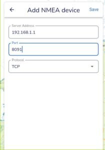
2. Add the Controller in Savvy Navvy
- Open the menu (top left) and choose NMEA Connect.
- Tap Connect device.
- Server Address:
192.168.1.1(the controller’s address on its own Wi-Fi). - Port:
8091 - Protocol: TCP
- Tap Save.
3. Check the Readings
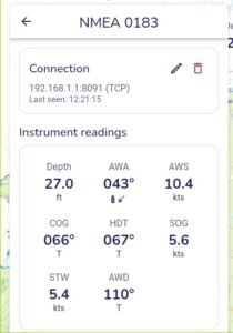
Within a few seconds the NMEA screen shows the connection and a Last seen time, with your instrument readings underneath. On our test bench Savvy Navvy showed depth, apparent wind angle and speed, wind direction, course and speed over ground, heading and speed through the water.
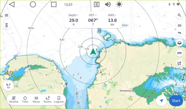
Back on the chart, the readings sit along the top of the screen. Tap one to choose what it shows. Your boat’s position now comes from your own GPS on the bus.
Good to Know
- If the controller is joined to your boat’s own Wi-Fi router rather than running its own network, use the address your router gave it instead of 192.168.1.1. The port is still 8091.
- Savvy Navvy shows what your instruments send. No wind sensor on the bus means no wind readings.
- To steer your autopilot, use the Nauti-Control app. On an Android tablet or the M22 display you can run it in split screen beside Savvy Navvy.
Questions? Leave a comment on the video or email admin@nauti-control.com.
Savvy Navvy is made by Savvy Navvy Ltd, which is not connected with Nauti-Control. Nauti-Control is a supplementary aid, not a replacement for your chartplotter or a proper lookout.

Leave a Reply
You must be logged in to post a comment.